Stand in parts of Tipton today and it can be difficult to imagine the landscape that surrounded previous generations.
Housing estates occupy former industrial land.
Green spaces cover areas scarred by mining.
Modern roads cross the sites of vanished works and collieries.
Canals that once carried heavily laden industrial boats are now used mainly for recreation.
Yet during the nineteenth and early twentieth centuries, Tipton stood within one of the most intensely industrialised landscapes in Britain.
Coal mines, ironworks, furnaces, factories, railway sidings and canals existed side by side.
To understand modern Tipton, we have to reconstruct that lost industrial landscape.
A landscape built on coal
Tipton’s industrial development was driven by geology.
Beneath the area lay extensive deposits of coal and ironstone within the South Staffordshire Coalfield.
Of particular importance was the celebrated Thick Coal seam of the Black Country. In places, several individual coal seams effectively combined to produce an exceptionally thick deposit.
Coal had been worked locally for centuries, initially through shallow pits where deposits could be reached relatively easily.
Industrialisation changed the scale completely.
Steam-powered pumping allowed deeper workings to be drained, while growing factories and ironworks created enormous demand for fuel.
Collieries consequently spread across Tipton.
Mining wasn’t something happening on the edge of the town.
It became part of the town itself.
Pits among the houses
Industrial communities frequently developed immediately alongside places of employment.
Workers wanted to live within walking distance of collieries, furnaces and factories.
Housing therefore appeared between and around industrial sites.
The result was a landscape very different from the separated residential and industrial zones familiar today.
A resident could leave a terraced house and encounter a colliery, canal basin, railway siding or ironworks within minutes.
Mining also created dangers above ground.
Old workings could cause subsidence, while spoil from pits accumulated into large mounds.
When collieries eventually closed, their physical legacy remained.
Ironworks and furnaces
Coal encouraged another enormous industry: iron.
Tipton possessed access to both the raw materials and fuel required for iron production.
During the eighteenth and nineteenth centuries, furnaces, foundries, rolling mills and engineering works spread across the district.
Names such as Tipton Green, Bloomfield, Gospel Oak, Ocker Hill, Princes End and Great Bridge became associated with different combinations of mining and manufacturing.
The skyline would have been dominated by chimneys and furnaces.
At night, the glow from industrial processes contributed to the image of the Black Country that became famous nationally.
This was not simply an industrial estate.
It was an entire industrial environment.
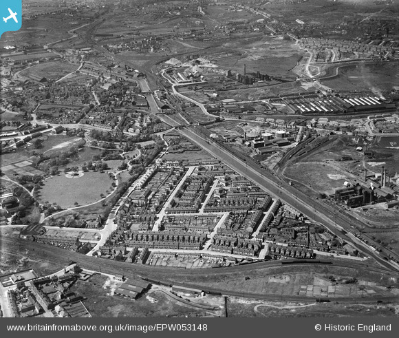
Tipton in 1937, with Victoria Park surrounded by canals, terraced housing, railway infrastructure and industry — a landscape very different from much of the town today.
Image credit: Photograph: Aerofilms Ltd · Source: Historic England Archive / Britain from Above · CC BY-SA · Image date: 19 May 1937
Canals through the factories
Few features reveal industrial Tipton as clearly as its canals.
The waterways were built primarily for commerce.
Coal was heavy and expensive to move along poor eighteenth-century roads. Canal boats could transport far greater loads efficiently.
As mining and manufacturing expanded, canal branches and basins reached towards collieries and factories.
The network became remarkably dense.
The original Birmingham Canal crossed Tipton on its journey through the Black Country. Later improvements altered levels and created more efficient routes.
Thomas Telford’s Birmingham New Main Line, opened in the 1820s, provided a straighter route through the industrial district.
Older waterways nevertheless remained useful.
This created the extraordinary network of old and new canals that survives around Tipton today.
Boats instead of bicycles
Modern visitors encounter towpaths used by walkers and cyclists.
The historic canal would have looked very different.
Working narrowboats carried coal, iron, limestone and manufactured goods.
Horses walked the towpaths.
Wharves and basins were busy workplaces.
Factories often turned towards the canal rather than away from it because the waterway provided their principal goods entrance.
Industrial buildings crowded the banks.
Smoke, noise and boat traffic were normal features of the canal environment.
The peaceful waterways surviving today can therefore give a misleading impression of their original purpose.
They were essentially industrial highways.
Railways cross the landscape
Railways added another layer.
Main lines carried passengers through Tipton, while goods lines and sidings connected factories and collieries with the national railway network.
At locations such as Dudley Port, canals, railways and roads occupied the same industrial corridor.
Bridges crossed bridges.
Railways crossed waterways.
Factories filled the remaining spaces.
Transport infrastructure became so closely intertwined with industry that removing factories later left bridges, embankments and canals apparently isolated from the purposes for which they had originally been constructed.
Industry creates communities
The industrial landscape also explains why Tipton developed differently from towns centred around one dominant historic core.
Employment was distributed across a wide area.
Communities developed around industrial concentrations.
Princes End had its own identity.
Ocker Hill had another.
Great Bridge became both an industrial and commercial centre.
Dudley Port developed around major transport connections.
Tipton Green formed another important focus.
People often identified strongly with these neighbourhoods.
Those identities survived even when the industries that originally supported them disappeared.
When the mines closed
Coal mining could not continue indefinitely.
Workings became exhausted, increasingly difficult to operate or uneconomic.
Pits closed.
But closing a colliery didn’t restore the landscape that existed before mining.
Shafts had to be made safe.
Spoil heaps remained.
Subsidence affected buildings and roads.
Contaminated ground restricted future development.
Water could accumulate in abandoned workings.
Across the Black Country, industrial decline therefore created a vast problem:
what could be done with the land left behind?
The disappearance of heavy industry
Mining wasn’t the only industry to decline.
Traditional ironmaking and heavy engineering also contracted during the twentieth century.
Some companies closed.
Others relocated.
Factories were demolished.
Railway sidings became unnecessary.
Canal basins were filled.
Industrial buildings that had dominated neighbourhoods for generations could disappear surprisingly quickly.
This created a strange situation.
The communities remained, but many of the physical reasons those communities had originally developed were gone.
Reclaiming the Black Country
By the post-war period, industrial dereliction had become a major challenge across Tipton and the wider Black Country.
Large areas of land required reclamation before they could safely support new development.
Spoil heaps were removed or landscaped.
Old mine workings were stabilised.
Contaminated sites were treated.
Abandoned industrial structures were demolished.
New roads were driven through former industrial districts.
Housing estates appeared on reclaimed land.
The transformation could be dramatic.
Land that earlier generations had known as pits or factories became almost unrecognisable.
The changing waterways
The canals experienced their own transformation.
Industrial carrying declined sharply as road transport became dominant.
Branches serving individual factories became redundant.
Some were abandoned or filled.
Others survived because they remained part of the navigable network.
Eventually attitudes towards the canals changed.
Waterways once regarded primarily as dirty remnants of obsolete industry became valued for recreation, wildlife and heritage.
Towpaths were improved.
Pleasure boats replaced much of the commercial traffic.
Walkers and cyclists began using routes once occupied by boat horses and industrial workers.
Tipton’s canals had acquired an entirely new purpose.
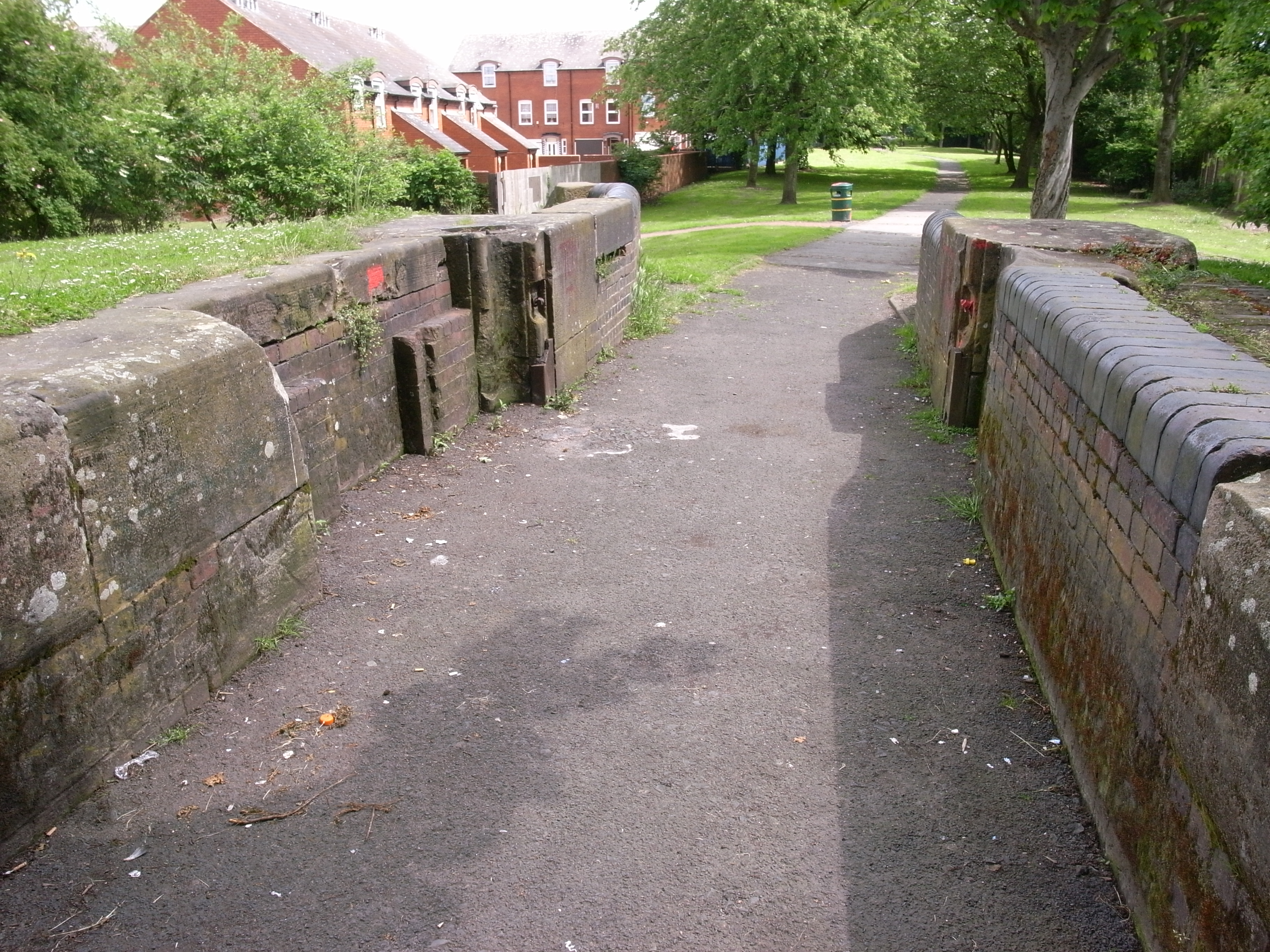
A surviving derelict lock on the former Tipton Green Canal, built in 1805 and abandoned after the canal closed during the 1960s.
Image credit: Photograph: Oosoom · Source: Wikimedia Commons · CC BY-SA 3.0 · Image date: 6 June 2008
Lost beneath modern Tipton
One of the fascinating things about studying Tipton is discovering what previously occupied apparently ordinary modern locations.
A housing estate may stand on a former colliery.
A supermarket or industrial unit may occupy the site of an earlier factory.
Open land may conceal filled mine workings.
An isolated bridge may once have carried a railway siding into works that no longer exist.
Even apparently unusual street layouts can make sense when compared with historic maps.
The modern town is therefore layered directly over industrial Tipton.
What survives?
Fortunately, industrial Tipton has not disappeared completely.
The canal network is the most obvious survivor.
Old bridges remain.
Railway infrastructure survives.
Occasional factory buildings and boundary walls provide clues.
Street names preserve the identities of vanished collieries and works.
Historic maps reveal even more.
Comparing an old Ordnance Survey map with the modern landscape can transform an ordinary walk.
Empty spaces suddenly become collieries.
Housing estates become furnaces and factories.
Modern roads cross vanished railway sidings.
Canal arms reappear beneath later development.
Why the lost landscape matters
Industrial archaeology isn’t simply about old factories.
The landscape explains how communities developed.
It explains why roads follow certain routes.
It explains why canals cross apparently unexpected places.
It explains the origins of neighbourhoods.
And most importantly, it preserves the experiences of generations who worked in industries that have almost completely disappeared.
Mining, ironworking and engineering shaped family life in Tipton for generations.
Removing the factories did not remove that history.
Two Tiptons
Tipton has effectively experienced two enormous periods of landscape transformation.
The first was industrialisation.
Fields and scattered settlements became collieries, furnaces, factories, canals, railways and densely populated neighbourhoods.
The second was deindustrialisation.
Mines and factories disappeared, derelict land was reclaimed, new housing was constructed and old transport infrastructure acquired new uses.
Modern Tipton is the product of both transformations.
That is why its surviving industrial features matter.
A canal bridge, abandoned railway alignment or fragment of factory wall may appear insignificant by itself.
But together they allow us to reconstruct a landscape that once defined the town.
Much of industrial Tipton may have vanished.
Its influence has not.