The Rowley Hills are one of the most distinctive natural landmarks in Sandwell.
Rising above the surrounding Black Country, they provide views across an urban landscape that stretches towards Birmingham, Dudley and beyond.
But these hills are more than simply high ground.
Beneath them lies a geological story hundreds of millions of years old — and a rock that became so valuable that generations of quarrying physically changed the shape of the hills themselves.
That rock became known locally as Rowley Rag.
Its extraction created employment, supplied construction projects far beyond Rowley Regis and left enormous scars in the landscape.
Today, the surviving hills tell two intertwined stories:
one created by geology and another created by industry.
A landscape before industry
Before the Black Country became heavily industrialised, the Rowley Hills stood above a predominantly rural landscape.
Fields, farms, tracks and small settlements surrounded the high ground.
Rowley Village developed close to the summit, while communities such as Blackheath, Old Hill and Cradley Heath grew elsewhere across the historic parish.
The elevation made the hills a prominent landmark long before large-scale quarrying began.
Their underlying geology, however, meant that they would eventually become valuable for something other than the views.
An ancient geological story
The distinctive rock beneath the Rowley Hills is a hard igneous rock generally described as dolerite.
It formed hundreds of millions of years ago when molten material forced its way through surrounding rocks and cooled underground.
Later erosion exposed this exceptionally hard material closer to the surface.
Locally it became known as Rowley Rag.
The name would eventually become almost inseparable from Rowley Regis itself.
Why Rowley Rag mattered
Rowley Rag possessed exactly the qualities required for heavy-duty construction.
It was extremely hard.
It resisted wear.
And once broken into suitable sizes, it provided excellent material for road building.
As towns expanded and road traffic increased during the nineteenth century, demand for durable roadstone grew enormously.
Rowley Regis possessed vast quantities of it.
What had been a geological curiosity became a major commercial resource.
Quarrying the hills
Stone had been extracted from the Rowley Hills on a smaller scale for generations, but industrialisation dramatically increased demand.
Large quarries developed.
Rock was drilled and blasted from the hills.
Huge quantities were crushed and graded.
Transport systems carried the finished material away.
Quarrying became one of the industries most closely associated with Rowley Regis.
But unlike a factory, which could eventually be demolished, quarrying permanently removed part of the landscape itself.
Every wagonload of Rowley Rag leaving the district represented a small piece of the Rowley Hills that would never return.
Working in the quarries
Quarrying was hard and potentially dangerous work.
Before modern machinery transformed the industry, much of the process relied upon physical labour.
Workers drilled into rock.
Explosives broke large sections away from the quarry face.
Stone then had to be broken, sorted, loaded and transported.
Dust was unavoidable.
So was noise.
Blasting carried obvious dangers, while unstable rock faces presented another hazard.
For generations of families, however, the quarries provided essential employment.
The hills were therefore not simply landscape features.
They were workplaces.
Moving millions of tonnes of stone
Extracting stone was only useful if it could be transported economically.
As quarry production increased, improved transport became essential.
Roads provided local connections, but railways became particularly important for moving large quantities of heavy stone.
Sidings and industrial railway infrastructure allowed quarry products to be transferred efficiently.
Rowley Rag could therefore travel far beyond the Black Country.
Stone extracted from a hill in Rowley Regis might eventually form part of a road many miles away.
This transport network helped turn a local geological resource into a commercially important product.
The landscape disappears
Large-scale quarrying had an extraordinary consequence.
Parts of the hills were literally being removed.
Historic maps reveal quarry workings expanding over time.
Deep excavations replaced earlier fields.
Quarry faces exposed the geology beneath the landscape.
Spoil and processing areas altered surrounding ground.
Routes changed as industrial workings expanded.
The familiar outline of the Rowley Hills was therefore partly shaped not only by geological forces but by human extraction.
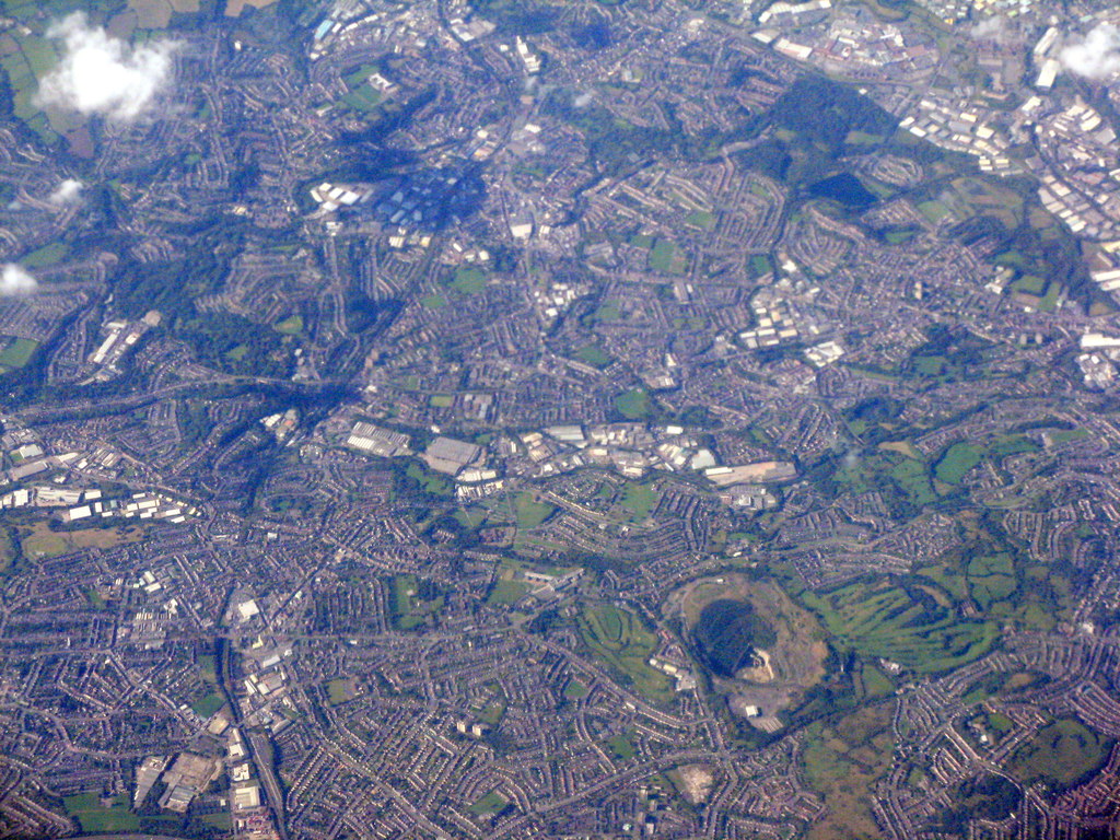
Aerial view across Rowley Regis in 2015, with a large stone quarry clearly visible within the Rowley Hills landscape.
Image credit: Photograph: M J Richardson · Source: Geograph Britain and Ireland · CC BY-SA 2.0 · Image date: 26 September 2015
Edwin Richards Quarry
One name became particularly associated with quarrying on the Rowley Hills: Edwin Richards.
The enormous Edwin Richards Quarry became one of the area’s dominant workings.
Its scale demonstrates just how important Rowley Rag extraction became.
Over time, the quarry created a huge excavation in the hills.
Even after active extraction declined, the quarry remained a major feature of the landscape — and eventually became the focus of debate over what should happen to such an enormous former industrial site.
From quarry to landfill
The end of quarrying did not necessarily mean the landscape could simply be restored.
Large excavations presented a difficult question:
what should be done with them?
Some former quarry sites became associated with waste disposal and landfill.
This created another chapter in the industrial history of the hills.
Land that had first been excavated for valuable stone could subsequently be used to receive material from elsewhere.
The landscape therefore experienced several successive transformations:
natural hill → industrial quarry → post-industrial site.
Industry all around the hills
Quarrying did not exist in isolation.
The wider Rowley Regis landscape was part of the heavily industrialised Black Country.
Coal mining took place nearby.
Iron and engineering works employed local residents.
Brickmaking and other extractive industries exploited different geological resources.
Railways and roads connected these industries.
From the high ground, generations of residents would have looked across a landscape filled with chimneys, collieries, furnaces and factories.
The hills were therefore both part of industrial Rowley Regis and a vantage point over the wider industrial region.
A changing Black Country
During the twentieth century, the industries surrounding Rowley Regis declined.
Coal mines closed.
Factories disappeared.
Traditional heavy manufacturing contracted.
Quarrying also became increasingly mechanised and concentrated.
The smoke-filled landscape associated with the Victorian and early twentieth-century Black Country gradually vanished.
Environmental expectations changed as well.
Industrial land was increasingly viewed as something that could be reclaimed, restored or given new purposes.
The Rowley Hills entered another phase in their long history.
Nature returns
Where heavy industrial activity has ceased, nature can reclaim surprising spaces.
Former workings can develop grassland, scrub and habitats for wildlife.
Exposed geological sections can also become scientifically valuable because quarrying has revealed rock formations that would otherwise remain hidden.
This creates an interesting contradiction.
Industry damaged and removed parts of the natural landscape.
Yet the excavations it created can themselves become important places for understanding geology and supporting wildlife.
The industrial and natural histories of the hills are therefore inseparable.
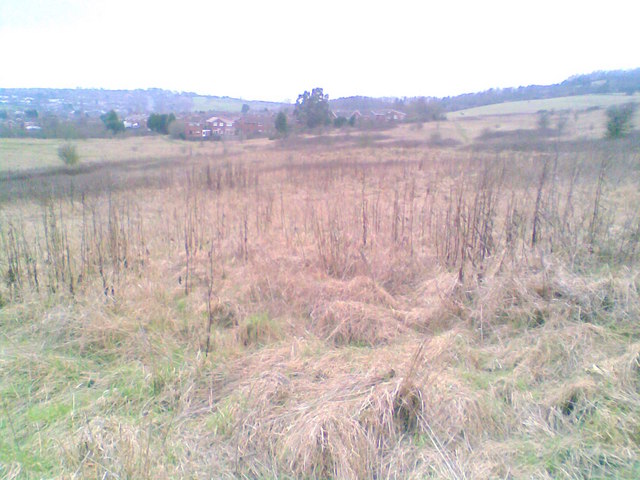
Portway Hill in Rowley Regis, part of the Rowley Hills landscape that has been shaped by geology, quarrying and later reclamation.
Image credit: Photograph: Burgess Von Thunen · Source: Geograph Britain and Ireland · CC BY-SA 2.0 · Image date: 9 February 2011
The hills as a landmark
Despite generations of quarrying, the Rowley Hills remain a defining feature of the local landscape.
Their elevation means they can be seen from many surrounding areas.
Likewise, viewpoints from the hills provide extensive panoramas across the Black Country and towards Birmingham.
For local residents, that visibility gives the hills an importance beyond geology.
They form part of the identity of Rowley Regis.
Factories can disappear.
Shops can change.
Roads can be rebuilt.
But the hills continue to provide a geographical anchor.
Reading the landscape
Historic maps are particularly useful for understanding how much the Rowley Hills have changed.
Comparing maps from different periods reveals quarries expanding across previously undeveloped ground.
Railway sidings appear.
Industrial buildings emerge.
Then later maps show industries disappearing or land changing use.
Modern aerial photography adds another layer.
Features that seem natural today can sometimes be revealed as reclaimed industrial ground.
Other apparently strange depressions or slopes make sense once earlier quarry workings are understood.
The landscape itself becomes an historical document.
Rowley Rag beyond Rowley Regis
One fascinating aspect of Rowley Rag is that much of the material extracted from the hills survives elsewhere.
The rock was valued precisely because it was durable.
That means stone removed generations ago may still exist as part of roads or construction works.
The industrial history of Rowley Regis therefore extends beyond the boundaries of the town.
Pieces of its geology were exported across the region and beyond.
Few industries demonstrate quite so literally how a local landscape could become part of the wider built environment.
What should survive?
The future of former quarry landscapes raises difficult questions.
Industrial sites can be dangerous.
They can require remediation.
Communities need housing and development.
But former quarries also contain geological, ecological and historical value.
Preserving every industrial feature is neither possible nor necessarily desirable.
Recording them, however, matters.
Photographs, maps, memories and surviving landscape features allow future generations to understand why the hills look the way they do.
Without that context, a former quarry can appear simply as an unusual piece of land.
With it, the same place becomes evidence of generations of work and dramatic environmental change.
The story written into the hills
The Rowley Hills existed long before Rowley Regis became an industrial community.
Geological processes created the rock.
People discovered its value.
Quarry workers extracted it.
Transport networks carried it away.
Industry changed the shape of the landscape.
And later generations inherited the enormous excavations left behind.
That is why the Rowley Hills are such an important part of local history.
They connect geology, industry, employment, transport, environmental change and community identity in one landscape.
Rowley Rag helped build roads far beyond the Black Country.
But its most dramatic legacy remains here.
It is written directly into the changing shape of the Rowley Hills themselves.